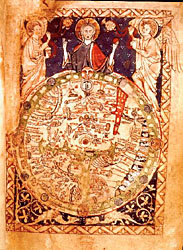
It is one of the earliest maps with Jerusalem at the center, reflecting the medieval world view.
Although tiny (15 cm x 10 cm), it contains a wealth of information. It is the earliest surviving map to symbolise Christ's power as overseer of the world, and one of the earliest maps to depict Biblical events -- for example, Moses crossing the Red Sea (the large red expanse, top right), and the earliest to display the "monstrous" races in Africa (the strange figures, some without heads, depicted on the right-hand edge).
The map shows the world with an encircling sea and three important waterways: the rivers Dan and Nile and the Mediterranean. They divide the land into three continents with Asia at the top, Africa bottom right and Europe in the bottom left quarter.
The map has east at the top; just below Christ is a depiction of Adam and Eve in the Garden of Eden. If the map is rotated so that north is at the top it becomes much easier to understand.